
Where are we going?!
This trip wasn't all what we planned. Originally, the plan was to do Rae Lakes Loop out of Kings Canyon National Park. However even though our permit was submitted more than 2 weeks out of our entry date, a ranger called and informed us there was only 1 permit left for that trail head. We requested a departure date of a day later and still had no luck. He gave us an hour to find another hike and get back to him. I was frantic. I googled "backpacking in Sequoia/Kings Canyon National Park" I was so unprepared and had little knowledge of the area. After a little bit of research Mineral King Timber Gap, Big 5 Lakes, kept coming up. We submitted our request for that loop and then waited for 2 weeks to receive our permit/conformation email.Mineral King is an area, only accessible by a very curvy twenty one mile long road, South East of the main entrance of Sequoia National Park. The road is narrow and usually takes an hour and a half to reach the ranger station.


Having two weeks to do some research (and last minute gear prep) we planned out our trip according to millage allowance for 4 days, campsite availability, and a map we found on a really helpful blog.
Mineral King Loop.

SO here is a quick break down for you.
TIME: allow for a MINIMUM of at least 4 days. If you're in GREAT shape (aka CLIMBING shape and are able to climb at least 1,000 feet per mile and just want to get this hike off your bucket list) then yeah you could do it in less, I wouldn't recommend it.
LENGTH: 28 miles. Again, It doesn't seem like much but every day has a pass (mountain range ) you have to climb over. My husband and I are athletic. I'm a Crossfitter and we both are marathon runners and triathletes. Living at sea level did us no favor for the 3,000 ft elevation changes.
We also wanted somewhat of a vacation so we took our time, took lots of pictures, and just relaxed if we got to campsites early.
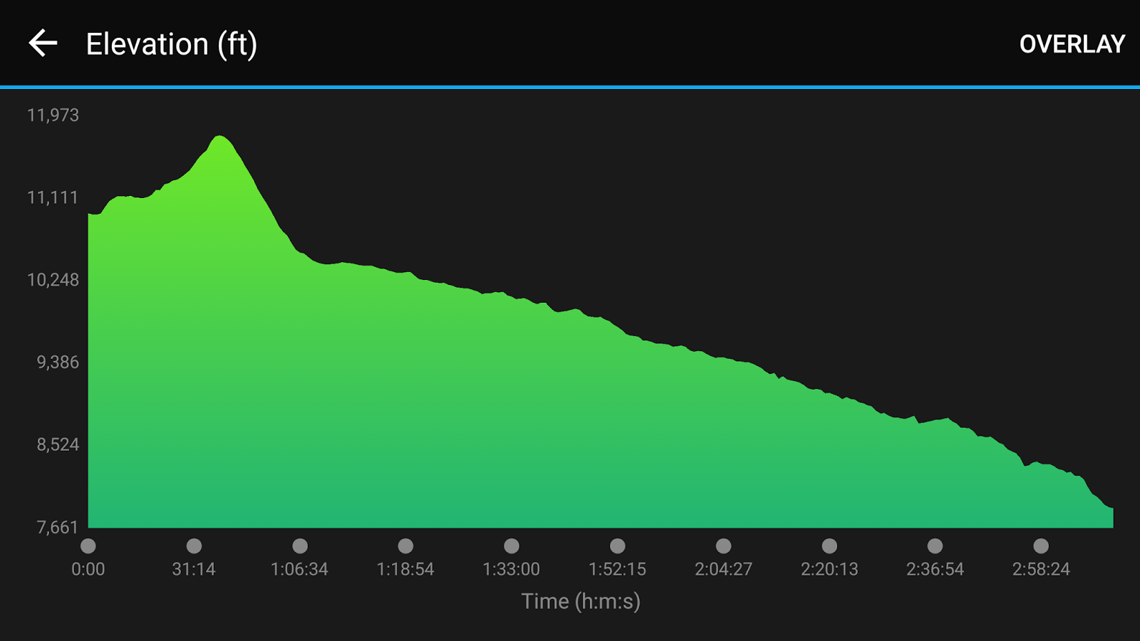
DIFFICULTY: I would rate it strenuous. Some of the valleys were gentle and pleasant, however, if you're not use to altitude the climbs are going to make it rough. Twice we hiked back to a valley and were surrounded by cliffs. I looked straight up and moaned "we have to climb this?". But up we went. On the climbs, we would average about 1 mile every 50 minutes. The rest of the hike, average hiking speed would be 1 mile every 29-33 minutes, depending on slope. (Referencing from Garmin Foreunner 220.)
SEASON / WEATHER: With our jobs, we are very fortunate to not have our lives revolve around a school calendar. We were able to sneak in before the busy labor day weekend (August 19th-22th) and basically have every lake/campsite to ourselves. At night I wore merino wool and had a 20 degree sleeping bag and was a little on the warm side. During the day hiking pants and a tanktop/tshirt was perfect, maybe even a little too warm still. We didn't deal with mosquito but still bought bug spray just in case.
Alright, here we go, "The wilderness must be explored"!
Day 1- Trail head to Pinto Lake, well, Almost.
The day we left, we drove in from Ventura, CA. It was about a 3.5 hour long drive. My husband had to work the night shift prior to us leaving so we didn't actually get to the ranger station until 1:50. We checked in, got our permit,and heard about Leave No Trace.We also asked about the marmot problem. If you google this hike you're likely see cars wrapped in tarps. During the summer marmots are very problematic and like to eat through engine hoses in cars. I came prepared with a car tarp but lucky for us, coming in late August, it wasn't an issue and didn't need to dress my car in a tarp.
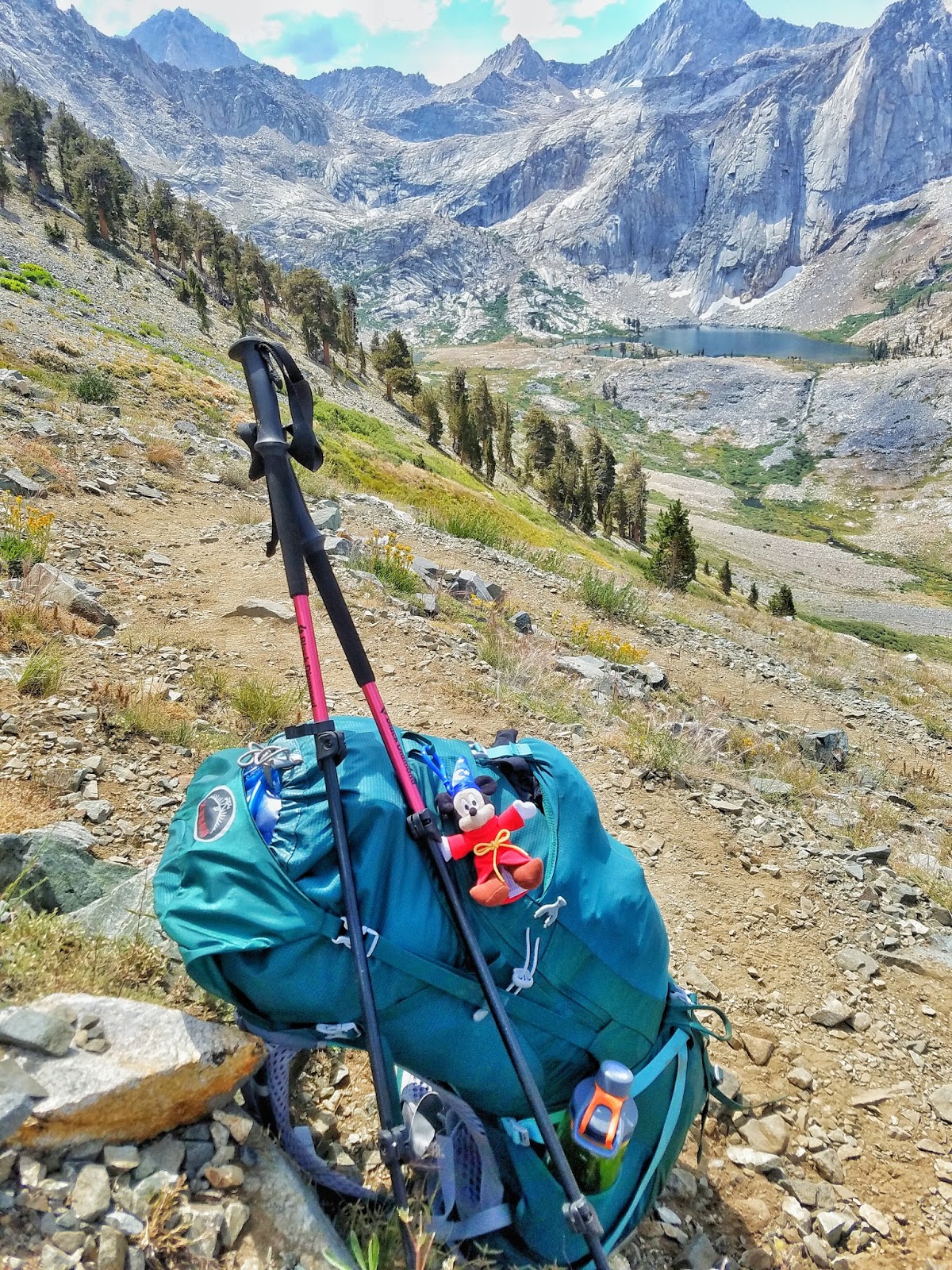
 |
| Our Packs. |


We knew in order to reach Pinto Lake before dark it would be a big haul, having started at 2:20pm. We still took moments to enjoy ourselves.
eventually it became evident our last .50 of a mile was going to be straight up a cliff side and over.

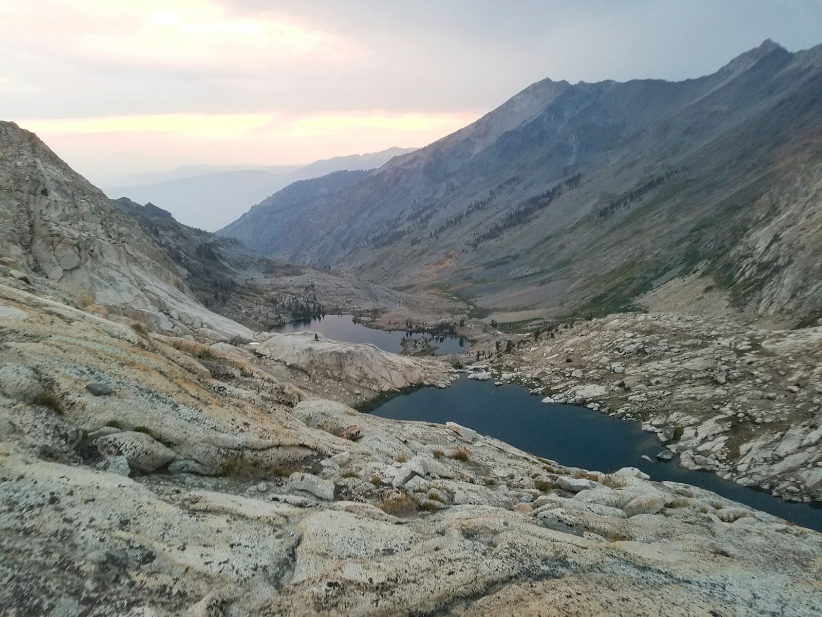
However halfway up, we stopped and got a glimpse of a beautiful sunset.


We were exhausted. After the climb I imagined this beautiful lake would be in front of us. However we were met with a marsh meadow. We spent about 25 minutes looking for a lake . After a while, we found a flat area, not far from a bear box, and called it a night. Our motor skills were quickly dwindling. The bear container lid was almost unlatchable due to our freezing hands and the lid to our Jetboil had became swollen shut due to elevation. Even setting up our tent took longer than usual. We got everything under control, All in the dark, but it is something we definitely laugh about now.


DAY 2- PINTO LAKE"ISH" TO UPPER BIG FIVE LAKES - WHAT A CLIMB TO BEAUTIFUL SERENITY.


We didn't hang around the campsite to long, according to my map's elevation I knew today was going to be a big climb.


AND FINALLY REACHED THE TOP OF BLACK ROCK PASS! Elevation 11,600
We celebrated with a goldfish and Twizzlers break


 .
.
Upper 5 Lakes Elevation 10,192
DAY 3 BIG FIVE LAKES TO COLUMBINE LAKE - "Oh what a beautiful morning"
We woke up to a beautiful morning. We took our time here, taking pictures, drinking coffee, eating oatmeal. How could you not love this?


Little did we know we played a little too long and the weather would catch up to us.


We made it to Columbine Lake! Elevation 10,970, Yes that's snow by his feet!
We had a great camping experience. Again, we were the only ones here the entire time. Unfortunately, the rain followed us and we had to put up our tent and gear pretty quick. It moved through fast and we had the rest of the evening to explore and take pictures.

DAY 4 COLUMBINE LAKE TO CAR- "Oh, HAIL"
We woke up to a BEAUTIFUL morning, again, spent a lot of time taking pictures, drinking coffee, and just enjoying the beauty of it all.


We made it to the top just in time to put rain jackets on when the thunder began. Josh says he saw lightening but decided not to tell me. The hail came soon after. We had no place to hide under, so down the mountain we flew. The other side is nothing but sand and gravel. At the beginning we were literally skiing down the 1,300 foot drop.

 We both were saying little prayers as we were flying down that mountain. The thunder was getting louder and louder every step we took. Things finally lightened up, we caught our breaths, and just laughed at what we just did. " We FLEW down that thing". We took a quick break at Monarch Lake to take in the view but headed on as the storm continued over the pass.

The terrain change drastically from white cliffs to beautiful forest.


Root beer float, Hamburger, chips, melon, and homemade pecan pie, OH MY


It was a life changing trip. So many times instead of thinking of what's next, I sat, and just let myself BE. I rarely looked at the time (mostly millage), and persevered through some challenging climbs.Some of moments I experienced took my breath away just by how beautiful this area really is. I love that places like this are a challenge to get to.
As I've previously stated, preparing for a backpacking trip makes you lay out the most minimal survival tools: food, shelter, water, and minimal comfort if room. When you enter the forest, it breaks you down to your most minimal version of yourself. It's you, your mind, body, heart, and soul. All complicated barriers but broken down into the most simplistic form, all coming together to experience the tranquility of the forest, as one.

. ...What's NEXT?...Maybe part of the John Muir Trail :)
GEAR/TIPS
I've very thankful to work at REI and am able to get some pretty high tech equipment goods. As far as gear 3 things I HIGHLY recommend for this trip, or any high elevation backpacking adventure:
- High wasted hiking pants (not jeans) or ones that even have a inner drawstring. My pack was rubbing on my hips by the 2nd day after I wore lower cut hiking pants. The higher cut adds more padding and comfort.
- Merino Wool Sleeping top (layered if can). I wore my amazing Smart wool 1/4 zip as well as a long sleeve Crew underneath
 I slept in it every night and was even a little too warm on 2 of the 3 nights ( as well as my down hooded Jacket)3. Trekking poles. This was the first trip I EVER used poles on. I always thought there were for the more slightly senior hikes. However with the elevation change, as well as important marathon in 2 weeks, I decided to check them out to help preserve my knees. These guys were my life line! They helped with distributing the weight of my pack in every direction. Mostly, they helped with my balance. My pack would pull me back as I would try to go up, they helped pull me and keep my pack moving with me. It saved me too when I would mistep, my pack going left, body going right. I'm a muppet after all.TIPS FOR THIS TRIPI honestly think we brought more water than we needed. In the middle of a drought, we're used to desert types of hikes . The multiple streams, lakes, and waterfalls we could have used as water sources. If you're too worried about weight I wouldn't bring more than 2 bladders (1 2L and 1 3L , or even 2 , 2L) not much more is needed after the first day.-Check YOUR WEATHER.This is a pretty standard tip but again, living by the beach in CA, you could be used to "it's sunny, it never rains" type of mindset. I ALMOST...ALMOST bought rain covers for our packs and now wish I would. Nothing got ruined but it could have. We REALLY lucked out when it came to the weather, it could have been a lot worse. Also temperatures are important. 2 weeks out it was forecasting in the 30's, the day before we left it moved to 40's. We were both warmer at night than we thought, again, we got lucky.-MEASURE YOUR MILESIf you're like me, you like data. Each day had a millage and elevation estimation. Both day 1 and 2 , according to my map and a blog, we were almost done, then a sign would pop up "2.9 miles!'...believe it or not that exact millage, twice, so..check and recheck. I just need to get better my map reading skills.Anyway, I hope you enjoyed and this trip report helps you plan for your next trip into Mineral King. Please feel free to contact me !
